How it works?
The principle
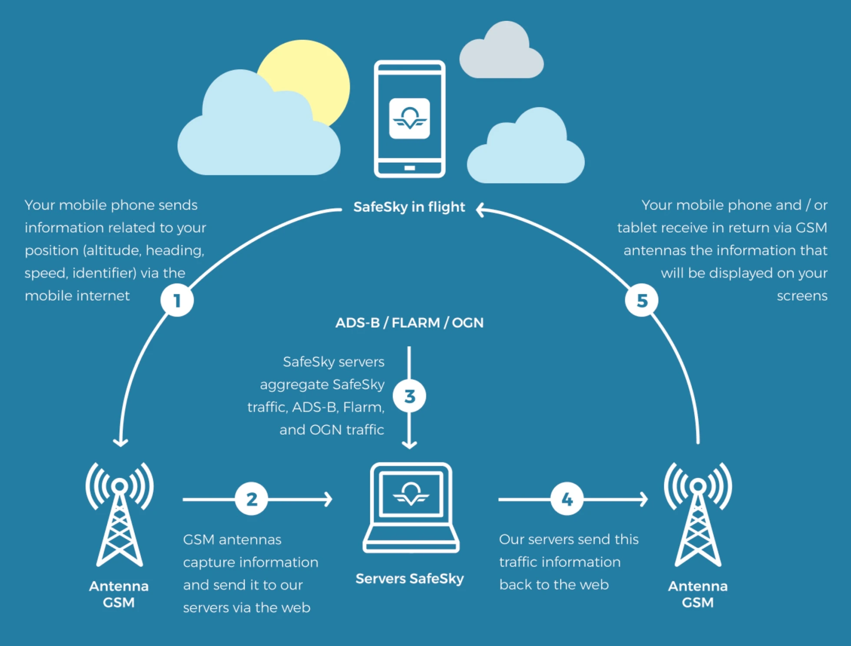
SafeSky is a mobile application designed for sharing real-time in-flight traffic information. Using the GPS chip of your mobile device, the SafeSky App sends your position to our servers, which then transmit it to other users of the application.
By doing so, you continuously share your position with the SafeSky community.
The exchange protocol is extremely lightweight, allowing position sharing even with a very weak mobile internet connection. While sending a text message in the air can be quite challenging, SafeSky manages to exchange data with minimal connectivity, as even an EDGE (2G) network is sufficient to transmit the few bytes needed for real-time traffic position sharing.
In addition to the traffic generated by the application itself, SafeSky aggregates traffic information obtained through its various partnerships or available from numerous ground stations managed and maintained by individuals, perhaps even by you. These stations provide highly precise positions of aircraft emitting ADS-B, Flarm, or OGN signals. SafeSky collects all this valuable information to add it to its own traffic data and provide you with the most comprehensive in-flight traffic information.
The visual below illustrates how SafeSky works:
 |
Equipped with radio transmission.
|
 |
Equipped with radio transmission devices and SafeSky (mobile internet).
|
 |
Equipped with SafeSky (mobile internet).
|
The internet
In Europe, the internet coverage is generally excellent. Based on our data since our existence, SafeSky has an 80% success rate for data transmission up to 5,000 feet. Although there may be occasional spots with no coverage, SafeSky will automatically reconnect once the connection is restored. Moreover, SafeSky's primary pilot base consists of pilots flying in E and G airspace classes, up to 5,000 feet AGL. Beyond that altitude, pilots typically operate in different airspace categories.
The visual below illustrates the efficiency of the mobile network across Europe:

Impact of topology, elevation and boundaries
SafeSky has proven to be particularly efficient in mountainous areas (Alps and Pyrenees) in numerous tests, with the high position of the antennae ensuring great mobile Internet coverage. This function allows you to be spotted despite the rocky massifs, which are a common obstacle for traditional radars. SafeSky is effective up to high flight levels, beyond FL90.
Tests have shown strong coverage up to FL45 in the plain, but SafeSky frequently permits to connect to the network considerably higher. White regions are areas of the territory that are fully inert and do not enable mobile internet connection. They are, fortunately, quite uncommon.
Crossing a border requires switching to a new mobile network operator, a process known as roaming. This usually results in a brief network loss (about 1 or 2 minutes) as the mobile connects to the new operator, similar to what happens when driving across borders.