Main Screen
SafeSky's interface is designed to be simple and user-friendly, allowing pilots to focus on their flight during operation.
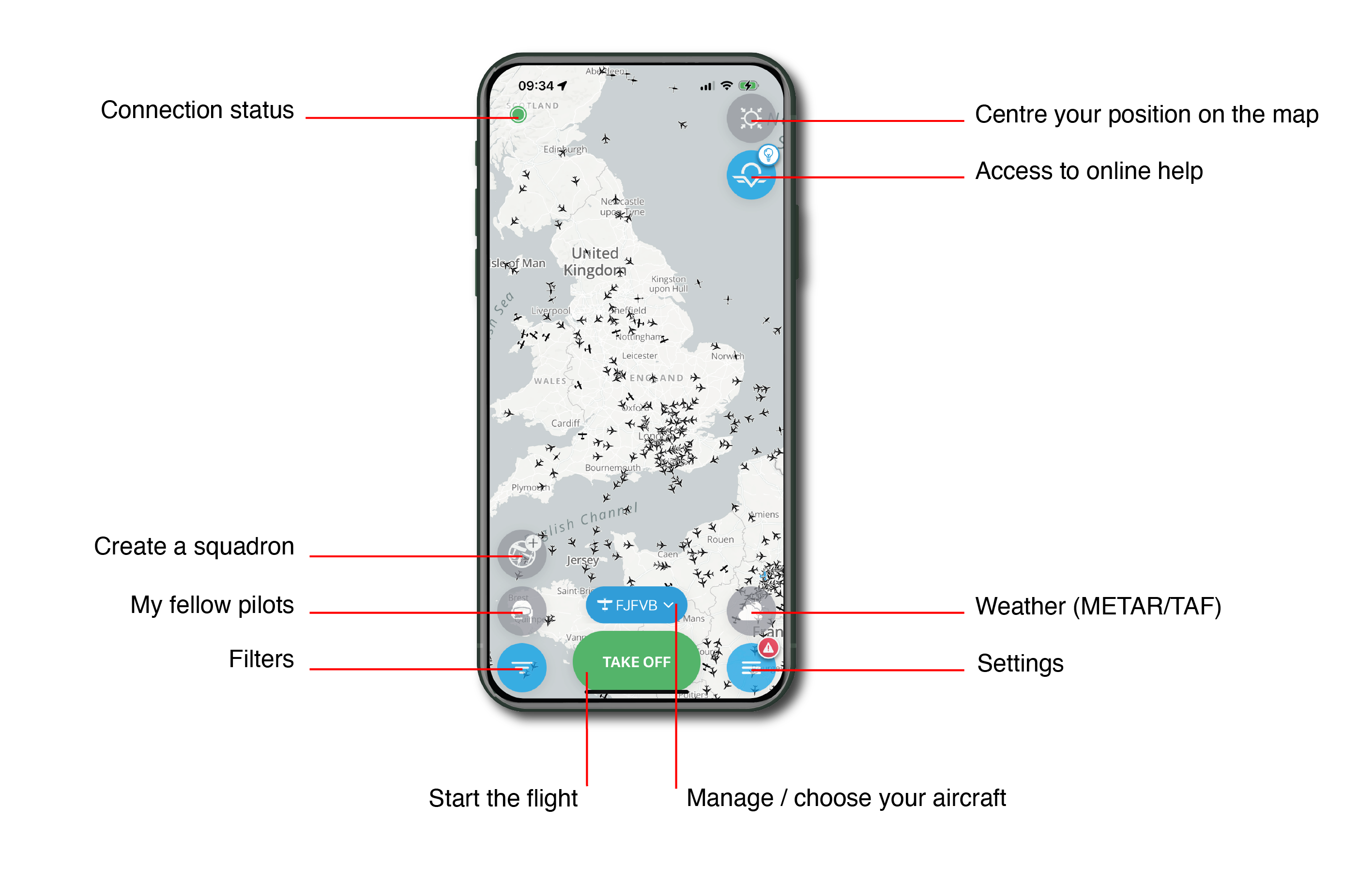
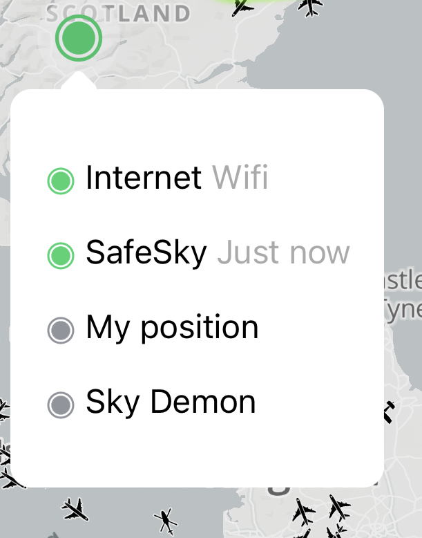
Connection status
This dot informs the pilot of the connection status, which can be either green or red, depending on its activity.
By clicking on the dot, a sub-window appears with additional information:
- Internet: indicates the status and activity of the internet connection.
- SafeSky: provides information about the last exchange with SafeSky servers.
- My Position: confirms if the mobile device's GPS is properly transmitting its position.
- <Navigation Software>: confirms the choice and connection to the selected navigation software in the application Settings.
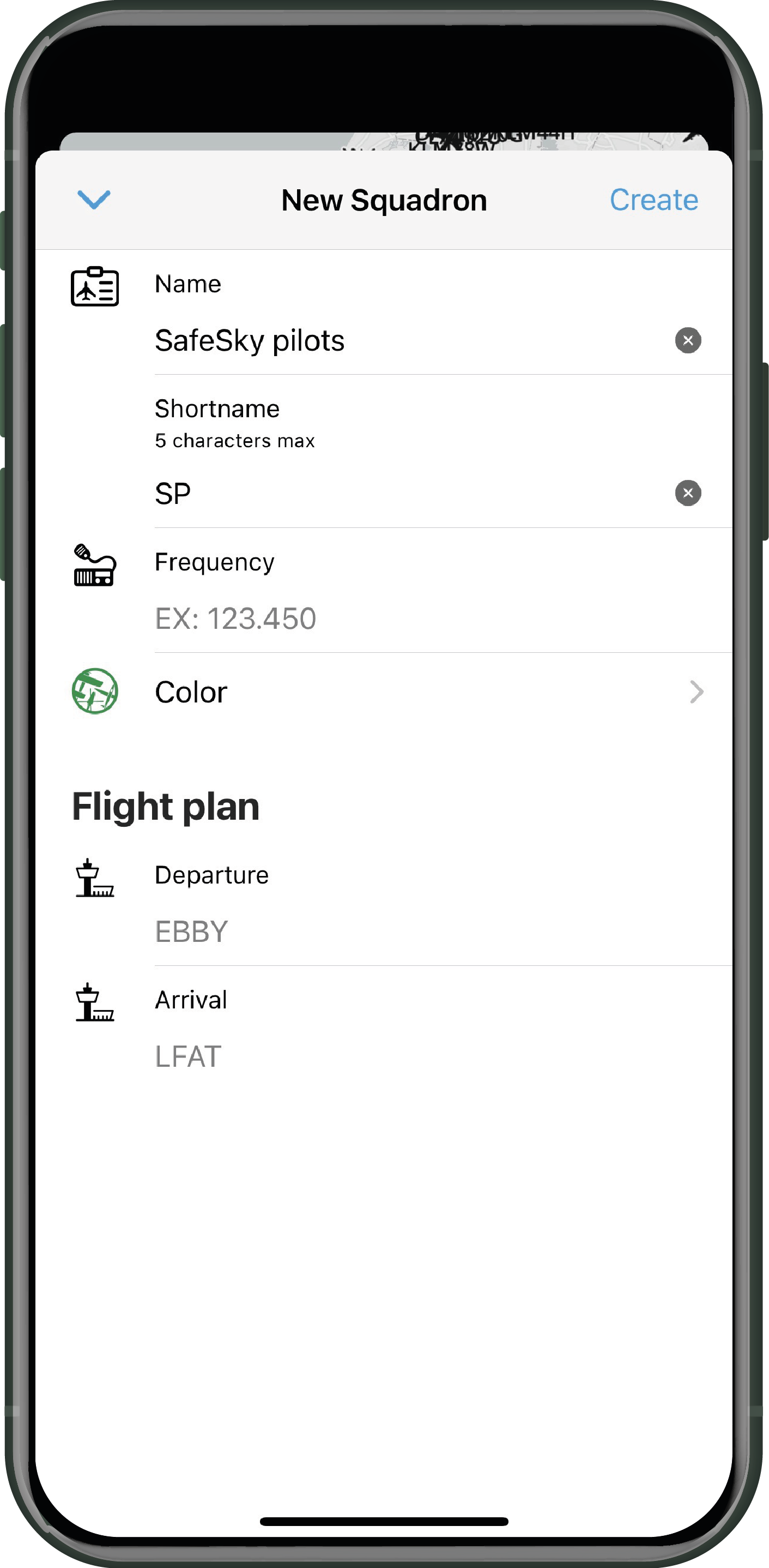
Creating a squadron

Inviter des amis pilotes à prendre part à prendre part à votre escadrille lors d'un vol. La création d'une escadrille permet d'afficher les avatars des appareils en vol dans une couleur précise afin de mieux les voir sur la carte, et annule les alertes de proximité entre les aéronefs d'une même escadrille.
L'accès à la création d'une escadrille est une fonction PREMIUM.
Procédez comme suit pour créer une escadrille:
- Cliquer sur l'icône "Escadrille" -
- Remplir les informations demandées (seul le nom de l'escadrille est indispensable) - Appuyer sur "Créer", en haut à droite. L'identifiant s'affichera sur les cartes à côté de l'indicatif de l'aéronef
- Inviter les pilotes avec qui vous voulez créer cette escadrille, en cliquant sur
 et cochez les amis pilotes de la liste que vous désirez voir rejoindre votre escadrille. Cliquer sur "Inviter" pour envoyer l'invitation directement par l'application.
Les invitations ne peuvent être lancées qu'à vos "Compagnons de vol".
- Votre ami pilote reçoit son invitation à rejoindre votre escadrille directement sur l'application SafeSky, et peut accepter ou refuser.
- Votre escadrille est créée et vous pouvez appuyer sur DECOLLER. Il n'y a pas d'alertes en vol entre les membres d'une même escadrille. L'icône des aéronefs de vos amis pilotes prendront la couleur de votre escadrille et cela même pour les autres pilotes utilisant SafeSky.
- Sur l'écran l'icône escadrille prendra la couleur choisie pour votre escadrille.En appuyant sur cette icône, à tout moment, vous aurez accès à un menu permettant de localiser vos amis, leur envoyer un message par l'intercommunautaire ou encore gérer votre escadrille (adapter ou supprimer)

My fellow pilots

If one or more of your fellow pilots (included in your SafeSky fellow pilots list - see the "Settings" chapter) is in flight, you can easily locate them on the map and send them pre-recorded messages if you wish.
Filters

By clicking on "Filters," you will access the following page:

|
|
If a red dot is displayed on the "Filters" icon, it means that filters have been applied. |
- Pressing "Reset" will return the application to its default settings.
- You can choose to enable or disable the display of grounded aircraft.
- The MAP filter interacts with the altitude of the aircraft displayed on the map.
-
This filter has no impact on the display of in-flight traffic when using the radar mode. It is solely intended for the display of traffic in map mode.
- The RADAR filter is important as it provides the visible traffic range in relation to your position. For example, in this case, the radar-visible traffic will be within the range of -3,500ft / +3,5000ft relative to your flight altitude.
- The following three filters are:
- Aircraft: Filters the type of aircraft you want to be displayed.
- Transponder: Filters the types of transponders aggregated by SafeSky you want to be displayed, including ADS-B, ADS-L, ASTERIX, FANET, FLARM, FLYING NEURONS, FLYMASTER, INREACH, MICROTRAK, MODE-S, NAVITER, OGN TRACKER, PILOT AWARE, REMOTE ID (Recreational Drones), SAFESKY, SPIDER, SPOT, XC GUIDE, XC TRACK. This list of transponders aggregated by SafeSky is continuously updated.
- Airport: Filters the types of airports you want to be displayed on the map (Airport, Ultralight Base, Hydrobase, Gliders, etc.).
-
Traffic displayed in black is traffic from compatible aggregated information sources. Traffic displayed in blue is traffic from SafeSky sources.
Center your position on the map

In map mode, pressing this button will automatically center your position on the map.
Access to online help
![]()
Here you will find a wealth of wealth of resources that walk you through the app's features and capabilities.
Weather

This feature provides access to weather information on the map, based on the latest METAR from airfields. The following information is accessible:
- Status:
- 🟢 VFR (Visual Flight Rules)
- 🔵 MVFR (Marginal Visual Flight Rules)
-
🔴 IFR (Instrument Flight Rules)
-
Gray color = METAR not updated for over 30 minutes
-
Cloud Base Altitude in feet
-
Wind direction and speed in knots
-
Horizontal visibility in kilometers

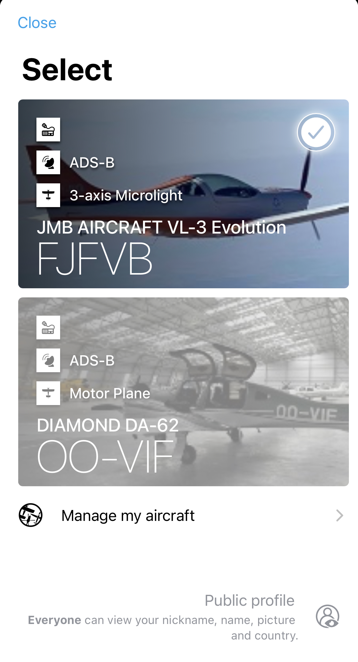
Select your aircraft

This button displays the call sign of the last used aircraft. If no action is taken, this aircraft will be used for the next flight. By clicking on this button, you can access the aircraft configuration page, giving you the option to choose another previously created aircraft or create a new one ("Manage my aircraft").
Only the PREMIUM version allows you to create more than one aircraft.
Settings

This section is where you can manage all of SafeSky's Settings. There is a dedicated chapter for it.
Take off

This is essential, as your position will not be shared with the SafeSky community without pressing "TAKE OFF".
If you wish to transfer traffic to a navigation software (SkyDemon, ForeFlight, or others), it is imperative to press "TAKE OFF" even while grounded. This action activates traffic sharing with compatible navigation software. Without "TAKE OFF" there will be no traffic on the navigation software's maps.
The "TAKE OFF" action will automatically display the radar screen.