What will you get?
TheYou principle
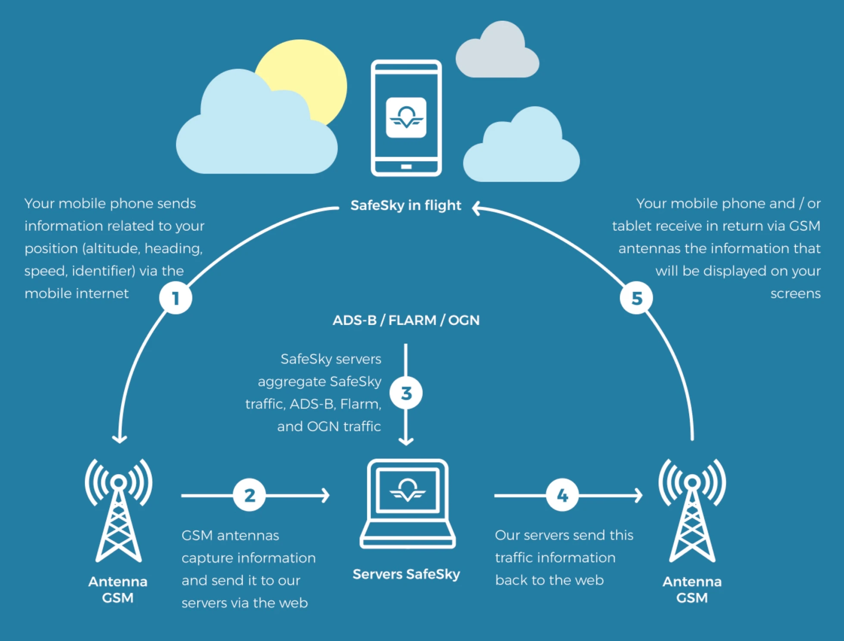
will SafeSky is a mobile application designed for sharing real-time in-flight traffic information. Usingget the GPSmost chip of your mobile device, the SafeSky app sends your position to our servers, which then transmit it to other users of the application.
By doing so, you continuously share your position with the SafeSky community.
The exchange protocol is extremely lightweight, allowing position sharing even with a very weak mobile internet connection. While sending a text message in the air can be quite challenging, SafeSky manages to exchange data with minimal connectivity, as even an EDGE (2G) network is sufficient to transmit the few bytes needed for real-time traffic position sharing.
In addition to the traffic generated by the application itself, SafeSky aggregatescomplete traffic information obtainedservice throughin-flight.
its various partnerships or available from numerous ground stations managed and maintained by individuals, perhaps even by you. These stations provide highly precise positions of aircraft emitting ADS-B, Flarm, or OGN signals.
SafeSky collects alland this valuable information to add it to its owndisplays traffic data from almost 20 different protocols, including ADS-B, FLARM, OGN, and providepartially youMode withS. theWhile mostit comprehensivemay in-flightnot show everything, it offers significantly more traffic information solution.than a single system or no system at all, without any extra hardware or financial cost.
TheUsing visualSafeSky belowcan illustratesgive theyou operationat ofleast SafeSky:"20 times more" traffic information, including exceptional traffic such as paramotor traffic. Of course, if other pilots aren’t using any detection device, SafeSky, like any other system, will not be able to see them. It’s like driving a car: if you do not turn on your headlights at night you cannot be seen … or too late.
The internet
In Europe, the internet coverageIt is generallyimportant excellent.to Basedacknowledge on our data since our existence,that SafeSky boastsis annot 80%a successradar, rateand fortherefore datanot transmission upintended to 5,000replace feet.any Althoughexisting theree-conspicuity mayequipment, besuch occasionalas spots with no coverage, SafeSky will automatically reconnect once the connection is restored. Moreover, SafeSky's primary pilot base consists of pilots flyingADS-B in Eor andFLARM G airspace classes, up to 5,000 feet AGL. Beyond that altitude, pilots typically operate in different airspace categories.
The visual below illustrates the efficiency of the mobile network across Europe:

Impact
Major ofprotocols topology,aggregated elevationby andSafeSky:
ADS-B
Asterix
Fanet
Flarm
Fly master
Flying Neurons
InReach
Microtrack
Mode S
Navigate
OGN tracker
Pilot Aware
SafeSky
Spider
Spot
XC-Guide
SafeSkyIf hasthis proventraffic would come to beclose, particularlyyou efficientwill inget mountainousan areasalert.
With the highPREMIUM position of the antennae ensuring great mobile Internet coverage. This function allows you to be spotted despite the rocky massifs, which are a common obstacle for traditional radars. SafeSky is effective up to high flight levels, beyond FL90.
Tests have shown strong coverage up to FL45 in the plain, but SafeSky frequently permits to connect to the network considerably higher. White regions are areas of the territory that are fully inert and do not enable mobile internet connection. They are, fortunately, quite uncommon.
Border crossing necessitates a change of operator, which is referred to as roaming. There is a relatively brief loss of network (of the order of 1 or 2 minutes in general), the time for the mobile to connect to the new operator, just as that is the case is in the car.
The offer
SafeSky offers both a Free and a PREMIUM plan. The Free Plan includes all safety features, including traffic information. The PREMIUM Plan offers added comfort and compatibility, particularly with navigation software and connectivity to your devices.
If you have opted for SafeSky PREMIUM,version, you can alsoseamlessly benefitintegrate fromand the GDL90 protocol (protocol allowing to viewdisplay this traffic inon your navigation applicationapp (SDVFR,and SkyDemon,eConspicuity ForeFlight,device. EasyVFR,