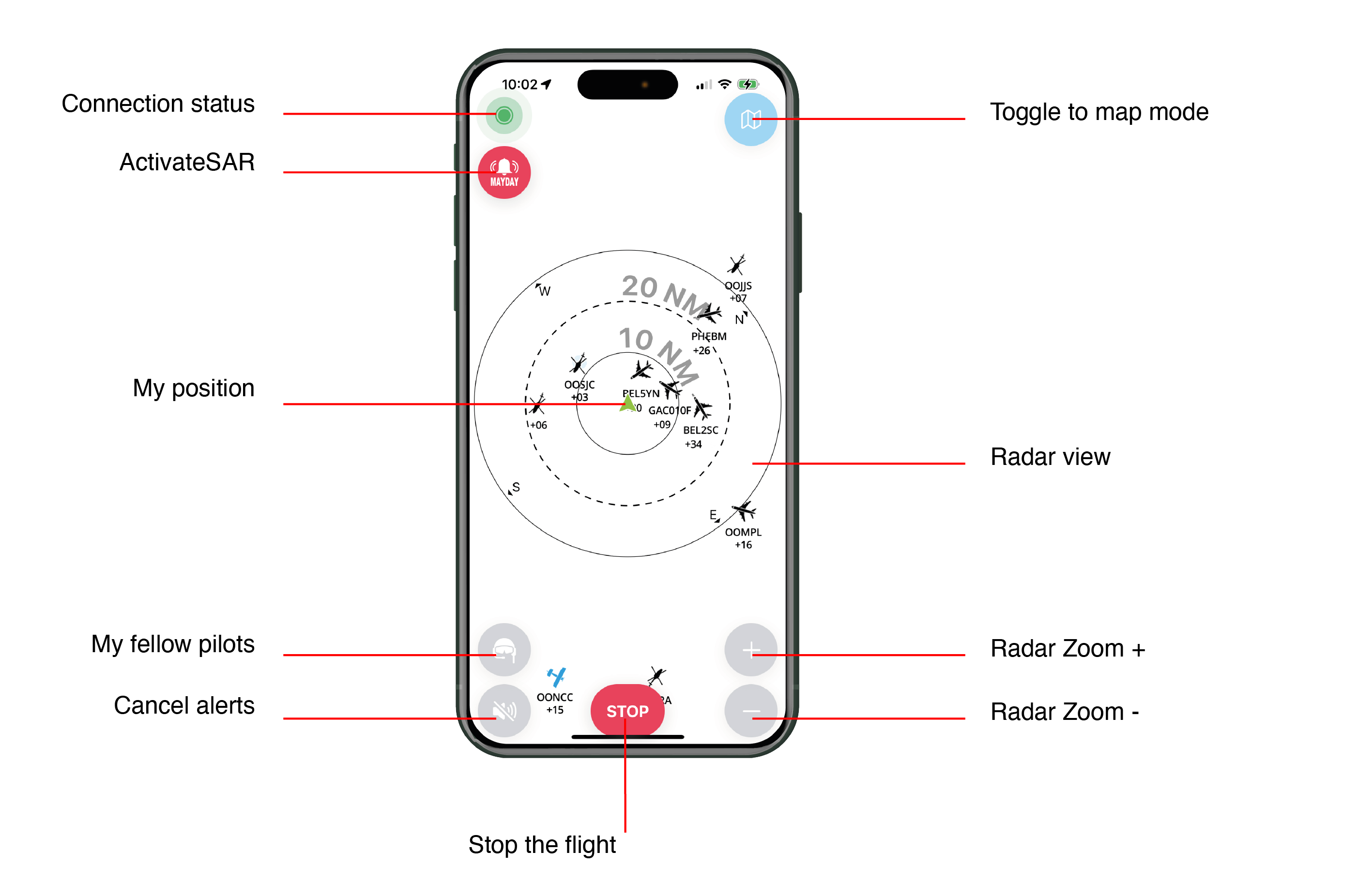
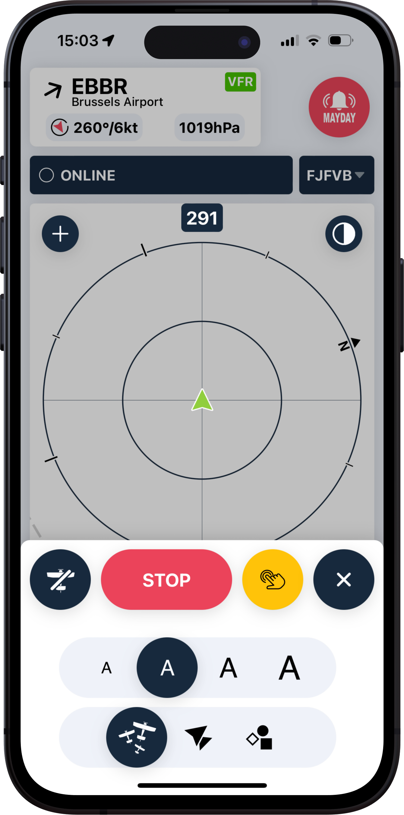
Radar screen
After hitting "TAKE OFF", the application will automatically display the radar screen.
Nearby weather - METAR/TAF
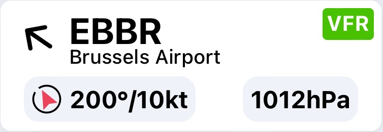
TheNearby weather near you is displayed dynamically as your flight progresses. You'll findreceive the following information:
- METAR station
concerned(ICAO code + name) - Weather conditions (VFR-MVFR-IFR)
- Wind strength and direction: the red arrow tells you which direction the wind is blowing, depending on your
heading.trajectory - QNH from the weather station
This feature is activated with the PREMIUM version.
Activate SAR (Search & Rescue)

Press this button during flight if you find yourself in a situation that could lead to an emergency landing. Simply activating SAR will trigger a series of actions detailed in the "Settings" section.
This feature is active in both the free and PREMIUM versions.
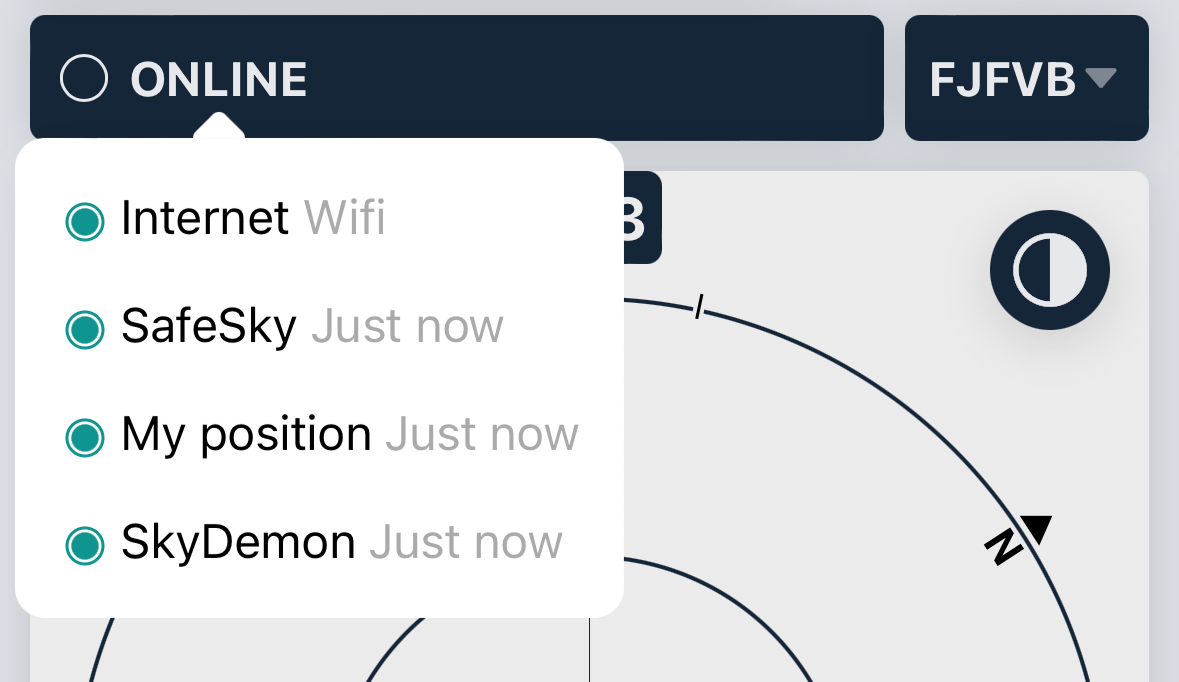
Connection status
This dot informs the pilot of the connection status, which can be either green or red, depending on its activity.
By clicking on the dot, a sub-window appears with additional information:
- Internet: indicates the status and activity of the internet connection.
- SafeSky: provides information about the last exchange with SafeSky servers.
- My
Positionposition: confirms if the mobile device's GPS is properly transmitting its position. - <Navigation Software>: confirms the choice and connection to the selected navigation software in the application Settings.
Change aircraft
If you are flying with severalmultiple aircraft, ensure you may have taken off withselect the wrongcorrect one.one Youin the SafeSky App. In case you forgot, you can changeswitch aircraft during the flight by accessing the list of registered aircraft. It is important to useUsing the correct aircraft configuration inis flightcrucial to ensure that you use the correctproper hexadecimal registration code foris registration.used.
Without being able to make the link betweenIf your SafeSky andconfiguration is not linked to your hexadecimal code /or registration number, thethere is a risk forof otheryour usersaircraft isbeing that they will see youdetected twice. This iscan notbe aconfusing situationfor thatboth improvesyou flightand safety.other pilots.
Modify background color
Depending on the brightnessoutside outside,brightness, you can chooseselect betweeneither a black or white radar background.
My position


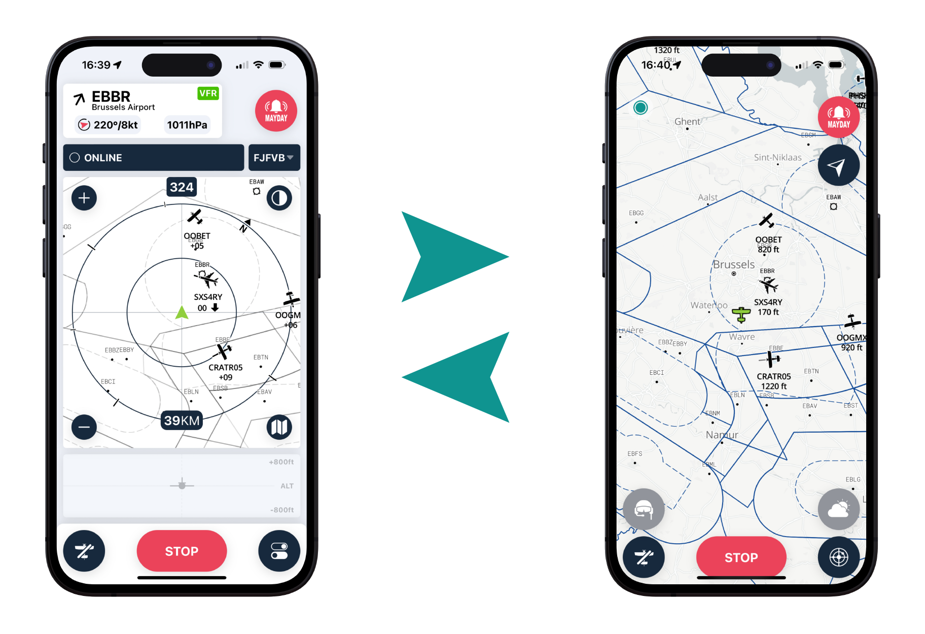
The centrecenter of the radar is, of course,represents your position relative to the surrounding traffic.traffic, This position is representedindicated by a green triangle. If youIn switch to map mode, your aircraft icon will also be green.
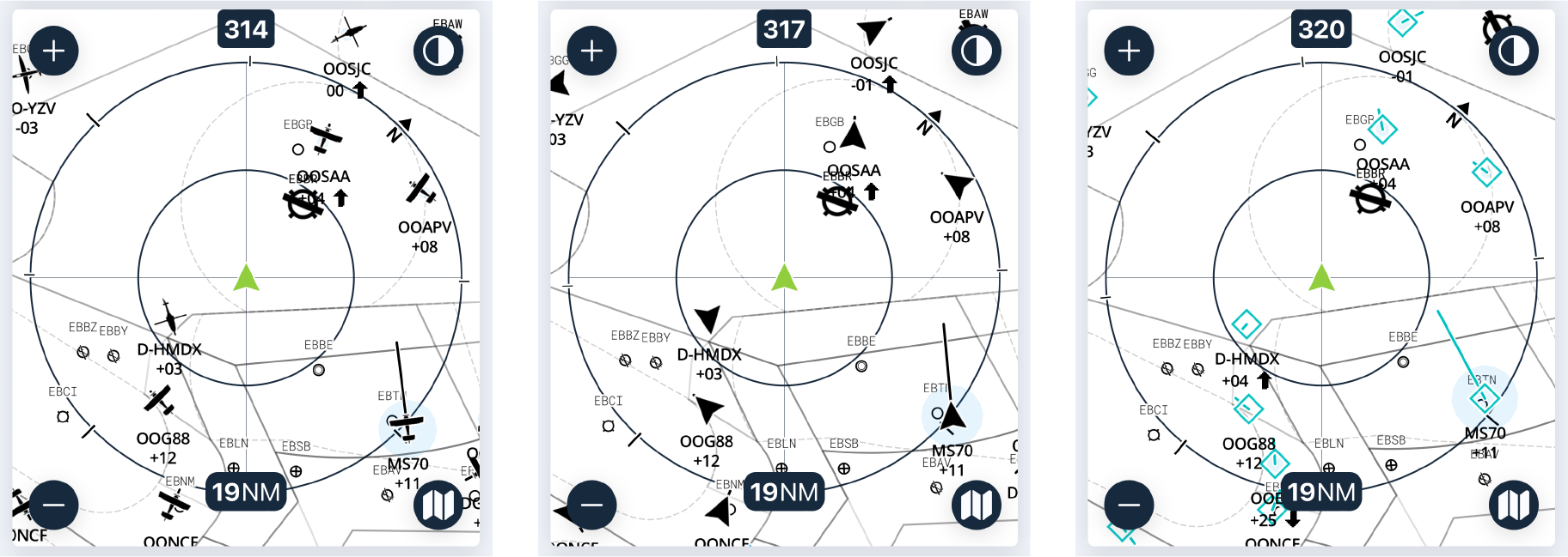
Radar zoom


Press "+" and "-" to decrease or increase the visible traffic distance on the radar. There are 4 zoom levels with the following scales:
- Up to +/- 0.5 nautical
miles,mile, or +/- 1 km - Up to +/- 1 nautical
miles,mile, or +/- 2 km - Up to +/- 2 nautical miles, or +/- 5 km
- Up to +/- 5 nautical miles, or +/- 10 km
- Up to +/- 10 nautical miles, or +/- 20 km
- Up to +/- 20 nautical miles, or +/- 40 km
- Up to +/- 40 nautical miles, or +/- 80 km
Quick Reminder: At 120 knots, an aircraft covers 1 nautical mile in 30 seconds of flight. It is, therefore, easy to calculate that an aircraft located within 2 nautical miles is approximately 1 minute of flight away (+/-). Of course, the speed of the aircraft is an important factor, and the speed vector should help you assess this distance/flight duration.
Go to map view

During the flight, you can switch from the radar screen to the map and vice versa by clicking on this symbol ![]() .
.
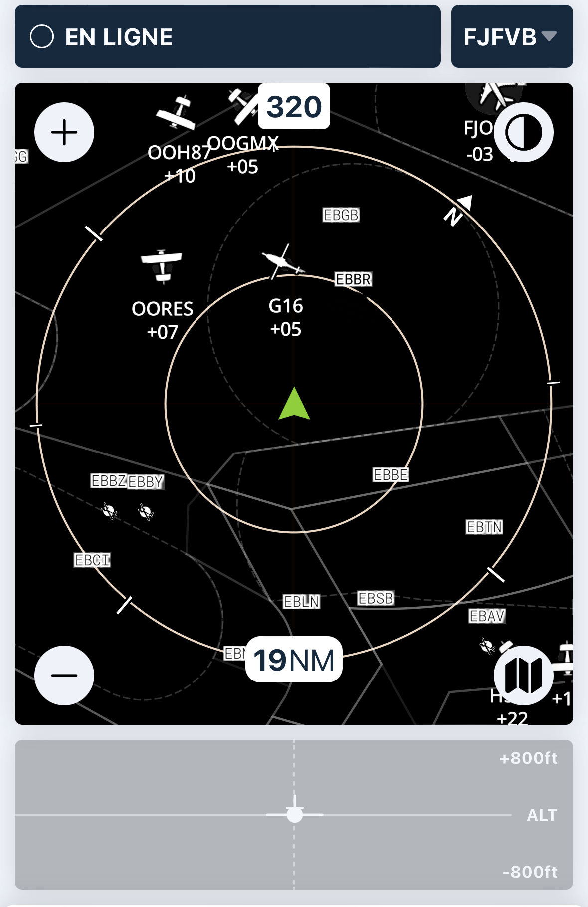
Radar
Radar representation using concentric circles incorporating the NORTH position, as well as the aircraft's course and the radar's largest radius (in our case below, 19NM). The radar can be configured in nautical miles (NM) or kilometres (kms).
 The radar will display the following elements:
-
Traffic: Shown as icons representing the type of visible aircraft, along with their callsign and relative altitude compared to your current position in flight. For example, +04 indicates that the traffic is 400 feet higher than your position, while -12 means it is 1,200 feet lower.
-
Airports: Airports are represented with their ICAO code, runway surface type, and orientation. A dashed line indicates a grass runway, while a solid line indicates a paved runway. If there is a METAR station at the aerodrome, click on it to display the METAR information.
- AIP: TMAs, CTRs and other zones are shown as watermarks. The aim is to give pilots familiar landmarks..
Alerts
If traffic is too close to your position, an orange or red cone will precisely alert you of its position. An audible alert can also be configured if you are using a Bluetooth headset.
During alerts, the screen will be frozen until the danger has disappeared, allowing the pilot to focus on the external surroundings rather than the inside. The zoom level will be automatically adapted.
FREE Version
If you have opted for the FREE version of SafeSky, the radar will alert you by considering a protection radius around your position. The intensity of the alert will be adjusted according to the proximity of other devices. SafeSky worked in this way until version 2.
PREMIUM Version
In its PREMIUM version, SafeSky offers, since version 3, a brand new algorithm that takes into account proximity on the one hand, but also the velocity and direction of aircraft. The result of this new way of processing traffic is to reduce the number of alerts that are not real dangers, thereby improving safety. In circuit, this new algorithm is particularly effective!
If traffic is too close to your position, an orange or red cone will alert you to its exact location. An audible alert can also be configured if you have opted for a Bluetooth headset.
During alerts, the screen is frozen to ensure that the driver is concentrating on the outside world and not on the application. The zoom level is automatically adjusted.


Traffic proximity alerts are both audible and visual. They can be intrusive if proximity is intentional, for example. In such cases, you can disable all traffic alerts. Click on the icon ![]() to access the detailed menu below:
to access the detailed menu below:
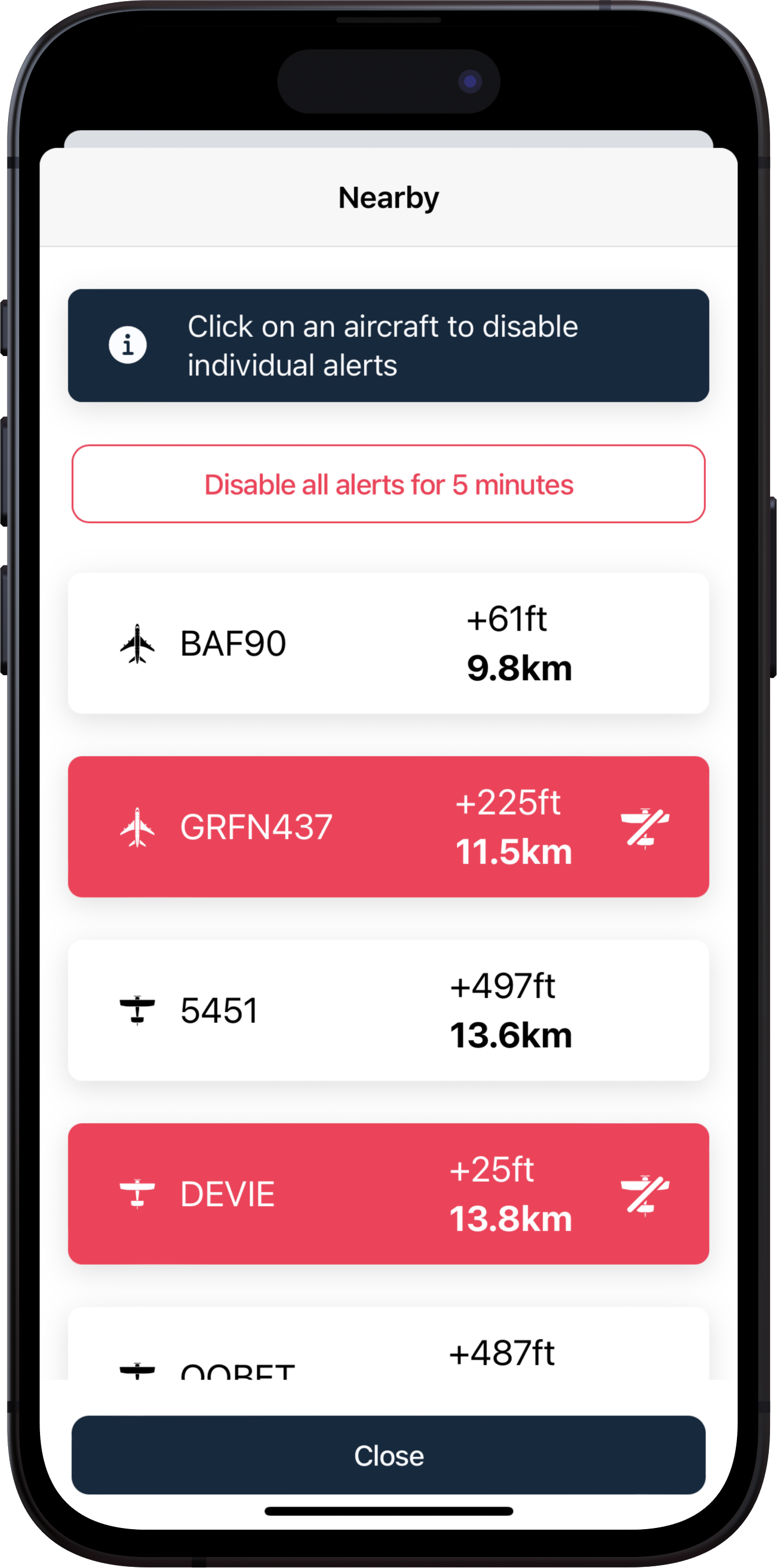
In this window, you can
- Deactivate all alerts for nearby aircraft for a period of 5 minutes.
- By clicking on the registration of an aircraft in the list, you will cancel the maps only for the aircraft selected for the duration of your flight.
Settings radar view

Clicking on this icon gives you quick access to basic settings so you can easily configure the font size and type of illustration for the traffic display.
Here are the 3 possible traffic representations (aircraft, triangles or "TCAS"):
Stop your flight

At the bottom of this screen, the red "STOP" button allows you to end your flight and stop sharing your position.
If you forget to stop the flight while grounded, the SafeSky application will automatically stop after 10 minutes of aerial inactivity.